Great Smoky Mountains National Park
The ultimate visitor guide to America's most visited national park, from scenic drives to hidden trails.
The 30-second answer
Great Smoky Mountains National Park is a massive, free-to-enter natural playground straddling the border of Tennessee and North Carolina. It offers over eight hundred miles of hiking trails, historic log cabins, cascading waterfalls, and some of the most spectacular scenic drives in the country. Whether you are looking for a strenuous hike up Mount LeConte, a leisurely drive through Cades Cove to spot black bears, or a quiet afternoon picnicking by a mountain stream, this park has something for everyone. However, its popularity means you need a solid plan to avoid the crowds, especially during peak seasons like summer and fall. You will need to purchase a parking tag if you plan to stop anywhere for more than fifteen minutes, but the entrance itself remains completely free. This guide will help you navigate the park like a pro, from choosing the right entrance to finding the best trails for your group.
What it actually is
Great Smoky Mountains National Park is a UNESCO World Heritage site and an International Biosphere Reserve, encompassing over half a million acres of protected forest. It is renowned for its incredible biodiversity, ancient mountains, and remnants of Southern Appalachian mountain culture. The park is divided into several distinct areas, each offering a unique experience. The Tennessee side, accessible primarily through Gatlinburg and Townsend, is the most visited and features iconic destinations like Cades Cove, Roaring Fork, and Mount LeConte. The North Carolina side, accessible via Cherokee, offers a quieter experience with highlights like the Oconaluftee Visitor Center and Cataloochee Valley.
Understanding the park entrances is crucial for planning your visit. The Gatlinburg entrance is the most popular and provides direct access to the Sugarlands Visitor Center, Newfound Gap Road, and the Roaring Fork Motor Nature Trail. This entrance is closest to Vantage locales in Gatlinburg and Pigeon Forge. The Townsend entrance, often called the "peaceful side of the Smokies," is your gateway to Cades Cove and is the most convenient option for guests staying in Wears Valley. The Cherokee entrance in North Carolina is ideal for accessing the Oconaluftee Visitor Center and the southern sections of the park.
The visitor centers are essential first stops. Sugarlands Visitor Center, located just inside the Gatlinburg entrance, offers extensive exhibits on the park's flora and fauna, a twenty-minute film, and a large bookstore. It is an excellent place to pick up maps, purchase your parking tag, and speak with park rangers about current trail conditions. On the North Carolina side, the Oconaluftee Visitor Center features the Mountain Farm Museum, a collection of historic log structures, and is a prime location for spotting elk in the early morning or late evening.
Hiking is the primary draw for many visitors, and the park offers trails for all skill levels. For an easy, family-friendly hike, Laurel Falls Trail is a paved, 2.6-mile roundtrip path leading to a stunning eighty-foot waterfall. It is one of the most popular trails in the park, so arriving early is essential. For a moderate challenge, the Alum Cave Trail offers incredible geological features, including Arch Rock and Alum Cave Bluffs, over a 4.4-mile roundtrip. For strenuous hikers, the trek to Mount LeConte via the Alum Cave Trail or Boulevard Trail provides breathtaking panoramic views and the chance to see the historic LeConte Lodge, the highest guest lodge in the eastern United States.
If you prefer to explore from the comfort of your vehicle, the park boasts several spectacular scenic drives. Newfound Gap Road (Highway 441) is a thirty-three-mile highway that crosses the mountains from Gatlinburg to Cherokee, offering numerous pullouts with expansive views, including the iconic Newfound Gap and Clingmans Dome. The Roaring Fork Motor Nature Trail is a narrow, winding, one-way loop accessible from Gatlinburg that takes you past rushing mountain streams, old-growth forest, and historic cabins. Little River Road connects the Gatlinburg entrance to Cades Cove, following the scenic Little River and providing access to numerous trailheads and picnic areas.
Waterfall hikes are another major attraction. In addition to Laurel Falls, Abrams Falls in Cades Cove is a popular moderate hike leading to a powerful, high-volume waterfall. Grotto Falls, accessible via the Trillium Gap Trail off the Roaring Fork Motor Nature Trail, is unique because you can actually walk behind the cascading water. Rainbow Falls, also off Roaring Fork, is a challenging hike that rewards you with a spectacular eighty-foot drop, which often produces a rainbow on sunny afternoons.
The park is also a sanctuary for wildlife. Black bears are the most famous residents, with an estimated population of over fifteen hundred in the park. Cades Cove and the Roaring Fork Motor Nature Trail are prime spots for bear viewing. White-tailed deer, wild turkeys, and woodchucks are also commonly seen. In the Cataloochee Valley and near the Oconaluftee Visitor Center, you can observe the majestic elk, which were successfully reintroduced to the park in 2001. Always remember to view wildlife from a safe distance and never feed the animals.
History buffs will find plenty to explore. The park preserves over ninety historic structures, including log cabins, barns, churches, and grist mills. Cades Cove is an open-air museum of pioneer life, with numerous preserved buildings scattered along the loop road. The Noah "Bud" Ogle Place near Gatlinburg offers a glimpse into a typical mountain farmstead, complete with a cabin, barn, and tub mill. The Elkmont Historic District, once a bustling logging town and later a resort community, features restored cabins and the fascinating "troll bridge."
Fishing is a popular activity, with over seven hundred miles of streams supporting wild trout populations. The park offers some of the best wild trout fishing in the eastern United States. You will need a valid Tennessee or North Carolina fishing license, and specific regulations apply, so be sure to check the park's official guidelines before casting your line. Picnic areas are scattered throughout the park, providing perfect spots to relax and enjoy a meal surrounded by nature. Popular picnic areas include Metcalf Bottoms, Chimneys, and Cades Cove.
In summary, Great Smoky Mountains National Park is a vast, diverse, and endlessly fascinating destination. Whether you are seeking adventure on the trails, a scenic drive through the mountains, or a quiet moment by a waterfall, the park delivers an unforgettable experience. With careful planning and a sense of adventure, you can discover the magic of the Smokies and create memories that will last a lifetime.
Best for and not for
Great Smoky Mountains National Park is best for outdoor enthusiasts, families looking for budget-friendly activities, and anyone who appreciates natural beauty and history. It is an incredible destination for hikers of all skill levels, from those seeking paved, accessible trails to experienced backpackers looking for multi-day treks. The park is also a paradise for photographers, offering endless opportunities to capture stunning landscapes, wildlife, and historic structures. Families will appreciate the educational opportunities at the visitor centers and the chance to explore nature together. The scenic drives make the park accessible to those with limited mobility, allowing everyone to experience the beauty of the mountains from their vehicle.
However, the park is not for those who expect a highly curated, theme-park-style experience. The natural environment is rugged and unpredictable. Weather can change rapidly, and facilities are limited once you leave the main visitor centers. Cell phone service is virtually nonexistent in most areas of the park, which can be a shock for those accustomed to constant connectivity. If you require modern amenities, extensive dining options, or guaranteed perfect weather, you might find the park challenging. Additionally, the park is not ideal for those who are highly averse to crowds, especially during peak seasons. The main roads and popular trailheads can become extremely congested, requiring patience and flexibility.
When considering group sizes, the park accommodates both solo travelers and large groups, but logistics can be tricky for the latter. Finding parking for multiple vehicles at a single trailhead is often difficult, and keeping a large group together on narrow trails requires coordination. For large groups, planning activities around spacious areas like Cades Cove or utilizing the larger picnic areas like Metcalf Bottoms is advisable. For those with mobility needs, the park offers several accessible options, including the Sugarlands Visitor Center, the paved Laurel Falls Trail (though it is steep in sections), and the numerous scenic drives. However, many of the park's most famous features require navigating uneven, rocky, or steep terrain.
Weather sensitivity is a crucial factor. The park experiences high humidity and frequent rain, especially in the summer. Thunderstorms can develop quickly in the afternoons. In the winter, higher elevations like Newfound Gap and Mount LeConte frequently see snow and ice, leading to road closures. If you are highly sensitive to heat, humidity, or cold, you will need to plan your visit carefully, focusing on the shoulder seasons or sticking to lower elevations during extreme weather. Always pack layers and be prepared for changing conditions, regardless of the forecast.
When to go
Timing your visit to Great Smoky Mountains National Park is the single most important factor in determining the quality of your experience. The park is open year-round, but the seasons dictate the scenery, the weather, and the crowd levels. Summer and fall are the busiest times, while winter and early spring offer a quieter, more solitary experience. Understanding the nuances of each season, as well as the best days of the week and times of day to visit, will help you maximize your enjoyment and minimize frustration.
Spring (March to May) is a time of renewal in the park. The weather is mild, though unpredictable, and the wildflowers are spectacular. The park is famous for its spring ephemeral wildflowers, which bloom before the trees fully leaf out. The Spring Wildflower Pilgrimage in April is a major event, drawing nature lovers from around the world. Waterfalls are at their peak flow during the spring, making hikes to Laurel Falls, Abrams Falls, and Rainbow Falls particularly rewarding. Crowds are manageable in early spring but begin to build as summer approaches. Weekdays are generally quiet, while weekends see an influx of regional visitors.
Summer (June to August) is the peak season for families. The weather is hot and humid, especially at lower elevations, but the higher elevations offer a cool respite. June brings one of the park's most unique and magical events: the synchronous fireflies at Elkmont. For a few weeks each year, thousands of fireflies flash in unison, creating a mesmerizing natural light show. Access to this event is strictly controlled via a lottery system, so advance planning is essential. Summer is also the best time for water activities, such as tubing on the Little River or wading in mountain streams. To avoid the worst of the summer crowds, arrive at trailheads before 8:00 AM or after 4:00 PM. Midweek visits are significantly less crowded than weekends.
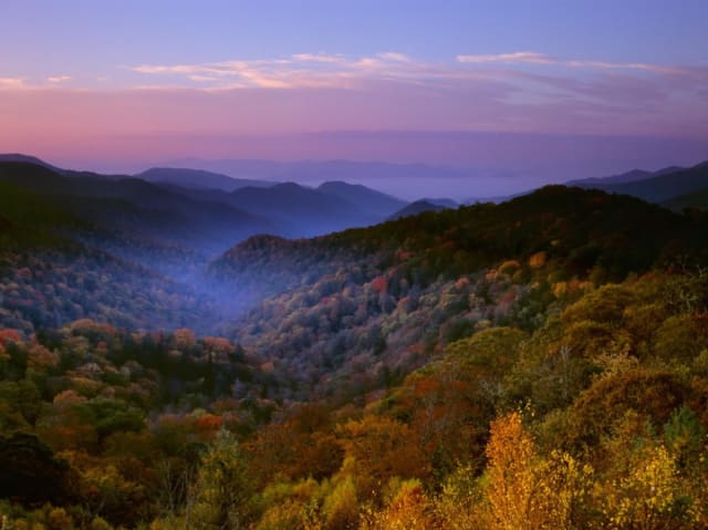
Fall (September to November) is arguably the most beautiful time to visit, but it is also the most crowded. The fall color peak typically occurs in mid-to-late October, drawing massive crowds to Newfound Gap Road and Cades Cove. The vibrant hues of red, orange, and yellow transform the mountains into a breathtaking canvas. Fall is also the rutting season for the elk in Cataloochee Valley, offering incredible wildlife viewing opportunities as the bull elk bugle and spar for dominance. If you visit in October, expect heavy traffic and full parking lots. To escape the crowds, explore less-visited areas like the Cosby or Greenbrier sections of the park, and always start your day as early as possible.
Winter (December to February) offers a stark, quiet beauty. The deciduous trees have lost their leaves, revealing the rugged contours of the mountains and opening up expansive views that are hidden during the rest of the year. Winter is the best time for solitude. You can often hike popular trails like Alum Cave or Chimney Tops without seeing another soul. However, winter weather is unpredictable. Snow and ice frequently close Newfound Gap Road and other higher-elevation routes. If you plan a winter visit, be flexible and check the park's road closure website daily. Winter is also an excellent time to explore the lower elevations, such as Cades Cove, which remains accessible year-round.
Regardless of the season, the best strategy for avoiding crowds is to arrive early. The most popular trailheads, such as Laurel Falls, Alum Cave, and the Grotto Falls parking area on Roaring Fork, often fill up by 9:00 AM. If you arrive later in the day, you will likely spend more time looking for parking than hiking. Alternatively, late afternoon and early evening visits can be rewarding, as the day-trippers begin to leave and the wildlife becomes more active. Just be sure to carry a flashlight and know your turnaround time to avoid hiking in the dark.
What it costs
As of May 2026, entrance to Great Smoky Mountains National Park remains completely free. You do not need to pay a gate fee to drive through the park, visit the visitor centers, or enjoy the scenic drives. This makes the park an incredibly budget-friendly destination for families and large groups. However, there is a significant cost associated with parking that you must be aware of.
The park implemented a "Park It Forward" parking tag program to help fund maintenance and improvements. If you plan to park your vehicle anywhere within the park boundaries for more than fifteen minutes, you must display a valid parking tag. The costs are $5 for a daily tag, $15 for a weekly tag, and $40 for an annual tag. These tags are required for all vehicle types and must be prominently displayed on your dashboard or hanging from your rearview mirror. You can purchase parking tags online before your trip, at automated fee machines located throughout the park, or at the visitor centers. It is important to note that a parking tag does not guarantee a parking spot at a specific location; parking is still on a first-come, first-served basis.
Beyond the parking tag, your costs will depend on your activities. Camping fees range from $30 to $40 per night for frontcountry campsites. If you plan to fish, you will need a valid Tennessee or North Carolina fishing license, which varies in price depending on your residency status and the duration of the license. Guided tours, horseback riding, and equipment rentals from concessionaires within the park will incur additional fees. However, the core experiences of the park, including hiking, scenic driving, and wildlife viewing, are entirely free once you have secured your parking tag.
Please note that the park is not included in the Xplorie program, as it is a federal public land with its own fee structure. However, the low cost of the parking tag makes it one of the most affordable major attractions in the region.
How to get there from each Vantage locale
Great Smoky Mountains National Park is easily accessible from all Vantage Stays locales, but your drive time and preferred entrance will vary depending on where your cabin is located. Understanding the best routes will save you time and help you avoid the worst of the local traffic.
From Gatlinburg, you are right on the park's doorstep. The Gatlinburg entrance is located at the south end of the Parkway. Depending on your specific cabin location, you can reach the Sugarlands Visitor Center in just five to fifteen minutes. This is the most convenient location for accessing Newfound Gap Road, the Roaring Fork Motor Nature Trail, and the Mount LeConte trailheads.
From Pigeon Forge, the drive is straightforward but can be congested during peak times. You will drive south on the Parkway (US-441) through Gatlinburg to reach the main entrance. The drive typically takes twenty to thirty minutes, but traffic in Gatlinburg can significantly increase this time. Alternatively, you can take the Gatlinburg Bypass to avoid the downtown traffic and connect directly to Newfound Gap Road.
From Sevierville, you have a slightly longer drive. You will follow US-441 South through Pigeon Forge and Gatlinburg. Expect a drive time of thirty-five to fifty minutes, depending on traffic. If you are heading to the Greenbrier or Cosby sections of the park, you can take Highway 416 East from Sevierville, which offers a quieter, more scenic route.
From Wears Valley, you have the distinct advantage of being close to the Townsend entrance, known as the "peaceful side of the Smokies." The drive from Wears Valley to the Townsend entrance takes only fifteen to twenty minutes via Wears Valley Road (US-321) and Townsend Wye. This is the absolute best route for accessing Cades Cove, Little River Road, and the Tremont area, allowing you to bypass the heavy traffic of Pigeon Forge and Gatlinburg entirely.
What to do nearby
While the park itself offers endless activities, there are several specific destinations within and immediately adjacent to the park that you should not miss. These locations provide focused experiences that highlight the best of the Smokies.
- Noah "Bud" Ogle Nature Trail: A fascinating glimpse into a historic mountain farmstead, featuring a preserved cabin, barn, and tub mill.
- Cades Cove Loop Road: The premier destination for wildlife viewing and historic structures, offering an eleven-mile scenic drive through a stunning valley.
- Abrams Falls Trail: A moderate hike located in Cades Cove that leads to a powerful, high-volume waterfall.
- Laurel Falls Trail: One of the most popular and accessible waterfall hikes in the park, featuring a paved path and a spectacular eighty-foot cascade.
Where to stay nearby
Choosing the right cabin can significantly enhance your national park experience. Vantage Stays offers incredible properties in Gatlinburg and Wears Valley that provide easy access to the park entrances while offering luxurious amenities to relax after a long day of hiking.
- A Perfect Getaway: A stunning Gatlinburg cabin offering easy access to the main park entrance and spectacular mountain views.
- Big Bear Retreat: A spacious Gatlinburg property perfect for large groups planning extensive park explorations.
- Dancing Bears Lodge: A cozy Gatlinburg retreat located just minutes from the Sugarlands Visitor Center.
- Great Smoky View: Enjoy panoramic vistas from this Gatlinburg cabin, providing a perfect basecamp for your adventures.
- Smoky Vista Lodge: A luxurious Gatlinburg option with premium amenities for post-hike relaxation.
- Amazing View Lodge: Located in Wears Valley, this cabin offers quick access to the peaceful Townsend entrance and Cades Cove.
- Paradise Found: A serene Wears Valley property perfect for those looking to escape the crowds while remaining close to the park.
Frequently Asked Questions
What are the operating hours for Great Smoky Mountains National Park?
The park is open twenty-four hours a day, three hundred and sixty-five days a year. However, certain roads, such as the Roaring Fork Motor Nature Trail and Clingmans Dome Road, are closed during the winter months. Visitor center hours vary by season, typically opening at 9:00 AM and closing between 5:00 PM and 7:00 PM.
Do I need to pay an entrance fee to visit the park?
No, there is no entrance fee to drive through or visit Great Smoky Mountains National Park. However, if you plan to park your vehicle anywhere within the park for more than fifteen minutes, you must purchase and display a valid parking tag ($5 daily, $15 weekly, or $40 annually).
What should I bring for a day hike in the Smokies?
You should always bring plenty of water, high-energy snacks, a physical map (cell service is unreliable), a first-aid kit, a flashlight or headlamp, and rain gear. The weather in the mountains can change rapidly, so dressing in layers and wearing sturdy, broken-in hiking shoes is essential.
Is the park accessible for visitors with mobility issues?
Yes, the park offers several accessible experiences. The Sugarlands and Oconaluftee Visitor Centers are fully accessible. The Laurel Falls Trail is paved, though it has steep sections that may be challenging for some wheelchairs. The scenic drives, such as Cades Cove and Newfound Gap Road, offer excellent views from the comfort of your vehicle.
Are dogs allowed on the trails in the national park?
Dogs are only allowed on two short walking paths in the park: the Gatlinburg Trail and the Oconaluftee River Trail. They are strictly prohibited on all other hiking trails to protect wildlife and preserve the natural environment. Dogs are allowed in campgrounds, picnic areas, and along roads, but must be kept on a leash at all times.
What is the best time of year to see black bears?
Black bears are most active in the early morning and late evening during the spring and summer months. Cades Cove and the Roaring Fork Motor Nature Trail are popular areas for bear viewing. Always maintain a safe distance of at least fifty yards and never approach or feed the bears.
Can I buy food inside the national park?
Food options inside the park are extremely limited. There are no restaurants or grocery stores within the park boundaries. You can purchase basic snacks and water at the visitor centers, but it is highly recommended that you pack a picnic lunch and bring all the food and drinks you will need for the day.
How do I avoid the crowds during peak season?
To avoid crowds, arrive at the park before 8:00 AM or after 4:00 PM. Explore less-visited areas like Cosby, Greenbrier, or Cataloochee instead of the main Gatlinburg entrance. Visiting on weekdays rather than weekends also significantly reduces the number of people you will encounter.
Is there cell phone service in the park?
Cell phone service is extremely limited and unreliable throughout most of the park. You may find a weak signal near the Gatlinburg entrance or at higher elevations like Newfound Gap, but you should not rely on your phone for navigation or communication. Always carry a physical map.
What is the parking tag system and how does it work?
The "Park It Forward" program requires all vehicles parked in the park for more than fifteen minutes to display a valid parking tag. Tags cost $5 per day, $15 per week, or $40 per year. They can be purchased online, at automated fee machines in the park, or at visitor centers. The tag must be visible on your dashboard.
Detailed Trail Guide: Exploring the Smokies on Foot
To truly experience the magic of Great Smoky Mountains National Park, you must leave your vehicle behind and explore its extensive network of trails. With over eight hundred miles of maintained pathways, the park offers an incredible diversity of hiking experiences, from gentle strolls along rushing streams to grueling ascents of the highest peaks in the eastern United States. This detailed guide breaks down some of the most iconic and rewarding trails in the park, categorized by difficulty, to help you plan the perfect hiking itinerary.
Easy Hikes for Families and Beginners
If you are traveling with young children, older adults, or simply prefer a leisurely walk in nature, the park has numerous easy trails that deliver spectacular scenery without the physical strain. The Gatlinburg Trail is one of the few paths in the park that allows bicycles and dogs. Starting near the Sugarlands Visitor Center, this relatively flat, 3.8-mile roundtrip trail follows the West Prong of the Little Pigeon River, offering beautiful water views and passing the foundations of several historic homes. It is an excellent option for a morning jog or a relaxed evening stroll.
Another fantastic easy option is the Porters Creek Trail in the Greenbrier section of the park. This trail is particularly famous for its spectacular display of spring wildflowers. The first mile is a wide, gentle gravel path that follows the cascading Porters Creek. Along the way, you will encounter remnants of the early pioneer settlement, including stone walls and the historic Ownby Cemetery. If you continue past the one-mile mark, the trail becomes slightly more rugged but leads to the beautiful Fern Branch Falls, making it a highly rewarding hike for minimal effort.
For a unique historical perspective, the Little River Trail in the Elkmont area is a must-visit. This wide, relatively flat trail follows the old logging railroad bed alongside the Little River. The gentle grade makes it perfect for families. As you walk, you will pass the restored cabins of the Elkmont Historic District, often referred to as the "ghost town" of the Smokies. The trail is particularly beautiful in the fall when the leaves change color, and it offers excellent opportunities for spotting wildlife, including river otters and various bird species.
Moderate Hikes for the Adventurous Day Hiker
For those seeking a bit more of a challenge, the moderate trails in the Smokies offer the perfect balance of physical exertion and breathtaking rewards. The hike to Andrews Bald is a classic example. Starting from the Clingmans Dome parking area, the Forney Ridge Trail descends through a fragrant spruce-fir forest before opening up onto Andrews Bald, the highest grassy bald in the park. The 3.6-mile roundtrip hike features some rocky and uneven terrain, but the panoramic views of the southern Smokies from the bald are absolutely spectacular, especially during the blooming of the Catawba rhododendrons in early summer.
The Trillium Gap Trail to Grotto Falls is another highly popular moderate hike. Located off the Roaring Fork Motor Nature Trail, this 2.6-mile roundtrip path winds through an old-growth hemlock forest. The highlight of the hike is Grotto Falls, a twenty-five-foot waterfall that you can actually walk behind. The cool, moist environment around the falls is a welcome relief on a hot summer day. Be aware that the parking area for this trailhead fills up very quickly, so arriving early is essential.
If you are looking for a hike that combines stunning water features with a solid workout, the Middle Prong Trail in the Tremont area is an excellent choice. This trail follows the Middle Prong of the Little River, passing numerous cascades and small waterfalls along the way. The trail is an old railroad grade, meaning the incline is steady but manageable. The highlight of the hike is Indian Flats Falls, located about four miles from the trailhead. The peaceful, less-crowded nature of the Tremont area makes this hike a favorite among locals and repeat visitors.
Strenuous Hikes for Experienced Trekkers
For experienced hikers seeking a serious physical challenge and the ultimate Smoky Mountain views, the park's strenuous trails deliver in spades. The hike to Mount Cammerer via the Low Gap Trail and Appalachian Trail is a grueling 11.1-mile roundtrip that tests your endurance. The trail climbs relentlessly from the Cosby Campground, gaining over three thousand feet in elevation. The reward, however, is unparalleled. At the summit, you will find a unique, octagonal stone fire tower built by the Civilian Conservation Corps in the 1930s. The 360-degree views from the tower deck, encompassing the Pigeon River Gorge and the surrounding peaks, are simply breathtaking.
The Boulevard Trail to Mount LeConte is another epic undertaking. While the Alum Cave Trail is the most popular route to the summit, the Boulevard Trail offers a longer, more solitary experience. Starting from Newfound Gap, this 16-mile roundtrip hike follows the Appalachian Trail before branching off onto the Boulevard Trail. The path rolls along the high ridge, offering continuous, sweeping views of the park. The high elevation means you will be hiking through a dense spruce-fir forest, an ecosystem more typical of Canada than Tennessee. Reaching the summit and the historic LeConte Lodge is a major accomplishment for any hiker.
Finally, the hike to Rocky Top and Thunderhead Mountain via the Anthony Creek Trail and Bote Mountain Trail is a strenuous 13.9-mile roundtrip that provides some of the most iconic views in the park. Starting in the Cades Cove picnic area, the trail climbs steeply to the Appalachian Trail. Once on the ridge, you will traverse several peaks, including the famous Rocky Top, immortalized in the popular country song. The views from the grassy balds along the ridge are expansive, offering a unique perspective on the Cades Cove valley far below. This hike requires excellent physical conditioning and plenty of water, but the sense of achievement and the incredible scenery make it a truly unforgettable experience.